Map created by EveryTrail: GPS Trip Sharing with Google Maps
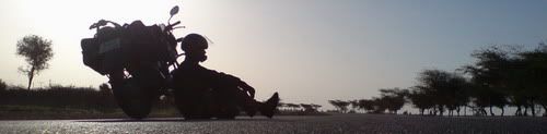
155 KMs Trip meter 12659
Going towards Mustang. First time taking a offroad trail in this trip. Seen a few pix of the area and was really tempting. Lot of uncertainty about rains and landslides etc. Travel agents were discouraging about the weather. But the hotel's watch man called a guy whe rides motorcycle in that area and said its ridable. Enquired about renting hartford offroad bike but was too expensive at 1000 rs and cant find guarantee for 2lakhs. So its gonna be on my trusted zma itself. There was a common opinion that if it rains (this is the rainy season here) life be very difficult. As always think of going till the last possible point and then decide. If not i can turn back and head to Butwal.
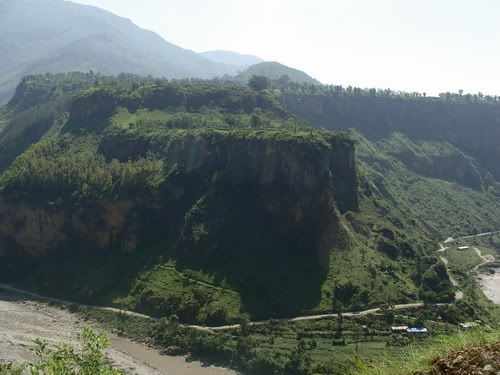
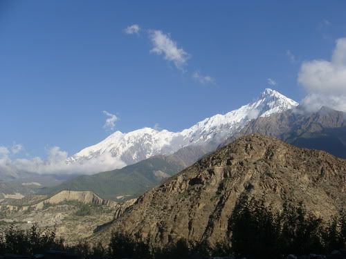
Left pokhara by 8 am. Reaching Jomsom was the the target for the day. All the while worried about rains. But the weather looked clear today. Hope its not a luring trap. Ride towards Baglung. Pretty nice road. The Machhapuchhare and Annapurna peaks are always in sight. When i had seen the same in a painting in Kathmandu, that was a strange imagination of the painter and how could there be a sharp and flat mountain next to each other. But here it is. Great weather and was a great morning ride as well. See some dramatic landscapes like tall cliff right next to river. Reach Baglung by like 10.30 and first thing was to fuel up. there is no availability of fuel ahead of here except may be in beni. Off all the people i asked no one was sure of the distance. But the idea was around 70 kms. Guess ZMA full tank should do it.
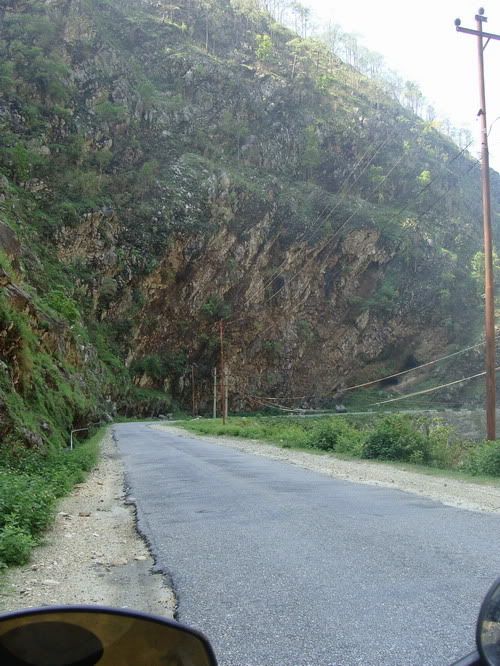
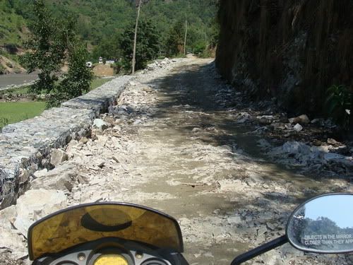
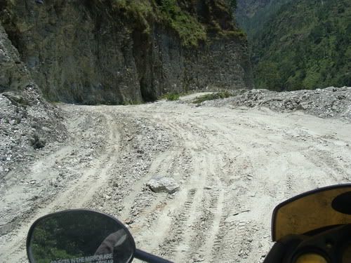
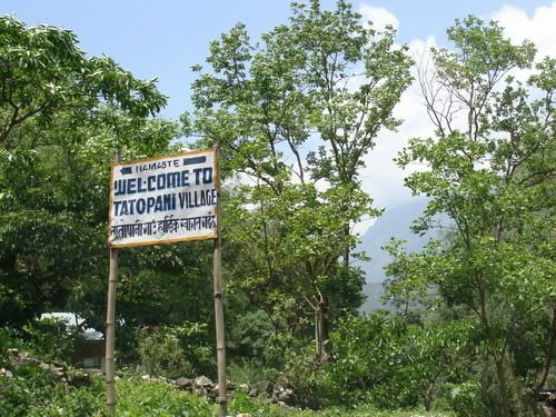
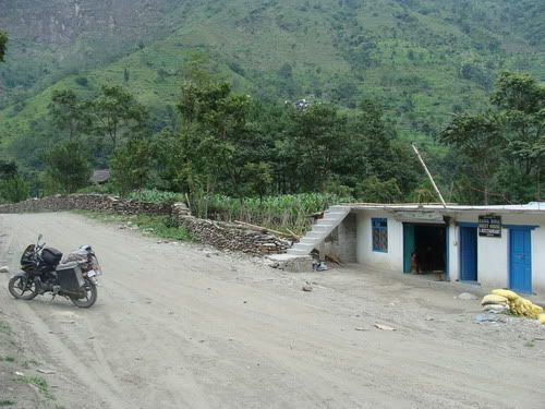
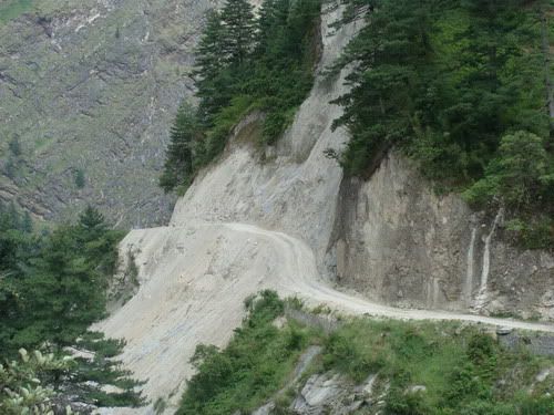
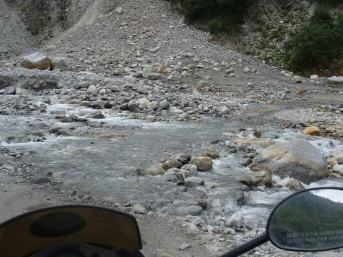
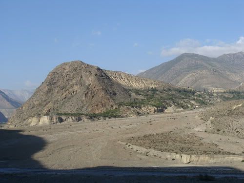
Took the road to Beni and in no time it was offroad. I had kinda heard that there was road till beni but its in process and just the stone and mud layer now. Immediately have to cross slush sections. Putting a lot of doubt in my mind. I heard that from Beni the path is ok/bettor than this stretch. Endure the relentless small bumps thanks to the stones. Reach beni and i was told path is bettor from here. I refuel to the grip again just in case. Yeah the path is bettor but no way smooth. A voice in my kept saying get back while you still can. But i kept going ahead hoping for bettor path. Few kms in i find 3 Europeans coming back on their rented Indian motorcycles. They were coming back from Marpha itself and said it only gets hards ahead and the same if it rains it will be hell. Hmmm... should i go back? but the bike wont turn and goes ahead instead. The weather is very clear today. Till Tatopani its totally on soft sand and some kinda dry slush sections. The slush monsters are sleeping. Hoping rains wont awaken them tomm i move ahead. There was some narrow on the wall landslide prone section. A truck guy said what i saw behind was nothing there is a danger area ahead. Asked, will my bike? and was instead asked? can you ride up there? !! Hmmm... ok Reach Dana and was hungry by now. They just had the last cup of rice while they had meat in plenty. There were a couple of encouraging truck guys. said the path will be fine after 10 kms, that is from lete village and its great near and after jomsom!! Well they said from trucker's point of view and i took it from biker's point of view!
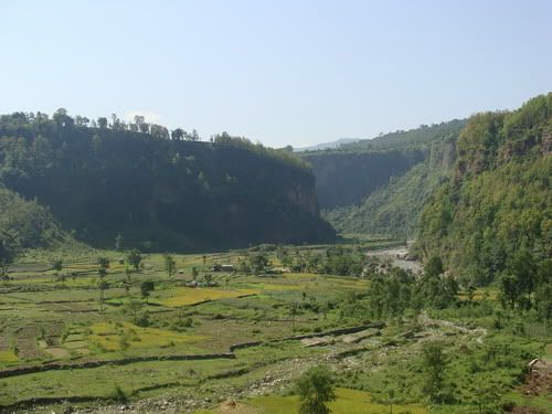
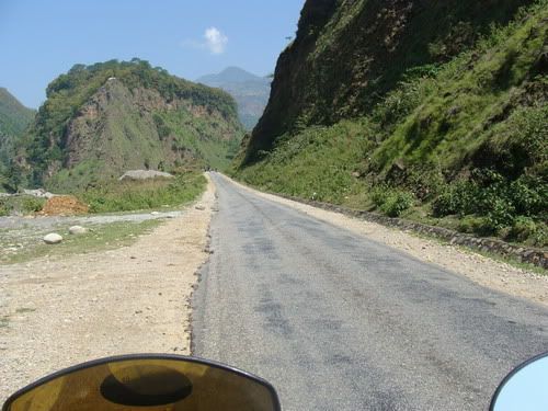
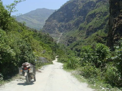
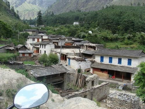
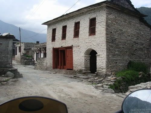
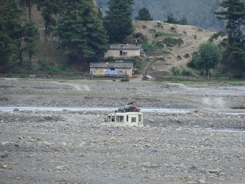
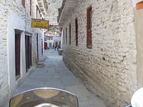
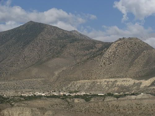
Start from Dana and in no time it was ride in the hairy section. The 'danger' part that people were talking about. It was tight narrow and trust me not very smooth. I move ahead looking for the elusive bettor path. Things ease out a bit after Ghasa. Meet this German trekker Fabian who was doing the Annapurna circuit trek. Was told about the dryness and windiness of the place ahead and did not give a good picture of the path ahead. Reach the town lete. Looked pretty but the main path had this horrible arrangement of stones in the name of the path! I would recon its not very comfy even to walk. The small high frequency bumps were very irritating. Wanted to get out of the town but this was a long town! Things here are still setup like a trekking trail as the road/path is new 1. There is absolutely no mechanical sympathy when the paths were being done. After lete it only got slightly bettor and no respite from bumps. It was getting late as well. I see a 4/4 taking a short cut by the river bend and was shaking a lot! so preferred the longer main path. The area ahead is supposed to be in rain shadow with not much rains. The tree life lessens and in not time riding in arid land. Its just a lil over 2k meters but the land scape was like 4k! The path smooths just a bit and now i cross town quicker. Pass tukche. Then get into Marpha village. I was riding in the path just wide enough for my bike with hotels, houses etc on either side. Only when i came out of the town did i realize that detoured into the town leaving the main bypass path. Any way it was fun riding in the narrow ally of Marpha.
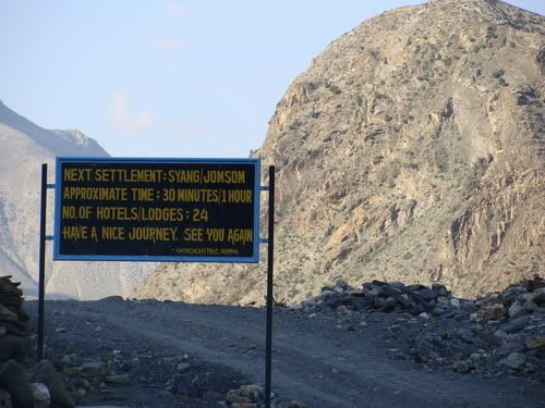
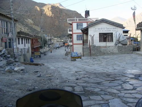
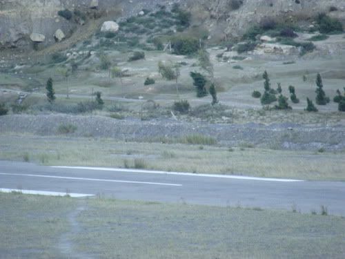
Next up is Jomsom around 30 mins a boards says. But thats for trekkers so must be pretty close i guess. Which it was. But the path with stones make it hard. It was very windy as well. Get to Jomsom by 6 pm. Wow i made it. I instantly fell in love with the town with a wide stone path and attractive buildings on either side. Just wanted to dump stuff and walk around the town. But not so soon! A cop shoes and does he checking. Sees my over due vehicle permit/ the letter given by Kathmandu police station. Some negotiation, weather i should be fined? Where's my entry permit for the restricted area? He was helpfull enough to advice me and helped me get a permit for going ahead. But i was kinda getting irritated i wanted to walk around the town before the light fades away. The Nilgiri view was splendid. Have heard of Nilgiri all my life and i finally see it in all its splendour in the clear weather. After 40 mins the cop finally lets me go. I get into this nice hotel Xanadu. There was a view of the airport and Nilgiri from the room. Very nice cozy place with a great restaurant. The light was still there around. It was pretty bright even at 7pm. Talk to a cop watching the airport and he gave me an insight of the weather of the place. Get tot he restaurant and have a coffee looking at the Nilgiri which was clearly visible even at 7.30 PM. Have dinner and retire for the night thinking about the tough day tomm.
Left pokhara by 8 am. Reaching Jomsom was the the target for the day. All the while worried about rains. But the weather looked clear today. Hope its not a luring trap. Ride towards Baglung. Pretty nice road. The Machhapuchhare and Annapurna peaks are always in sight. When i had seen the same in a painting in Kathmandu, that was a strange imagination of the painter and how could there be a sharp and flat mountain next to each other. But here it is. Great weather and was a great morning ride as well. See some dramatic landscapes like tall cliff right next to river. Reach Baglung by like 10.30 and first thing was to fuel up. there is no availability of fuel ahead of here except may be in beni. Off all the people i asked no one was sure of the distance. But the idea was around 70 kms. Guess ZMA full tank should do it.
Took the road to Beni and in no time it was offroad. I had kinda heard that there was road till beni but its in process and just the stone and mud layer now. Immediately have to cross slush sections. Putting a lot of doubt in my mind. I heard that from Beni the path is ok/bettor than this stretch. Endure the relentless small bumps thanks to the stones. Reach beni and i was told path is bettor from here. I refuel to the grip again just in case. Yeah the path is bettor but no way smooth. A voice in my kept saying get back while you still can. But i kept going ahead hoping for bettor path. Few kms in i find 3 Europeans coming back on their rented Indian motorcycles. They were coming back from Marpha itself and said it only gets hards ahead and the same if it rains it will be hell. Hmmm... should i go back? but the bike wont turn and goes ahead instead. The weather is very clear today. Till Tatopani its totally on soft sand and some kinda dry slush sections. The slush monsters are sleeping. Hoping rains wont awaken them tomm i move ahead. There was some narrow on the wall landslide prone section. A truck guy said what i saw behind was nothing there is a danger area ahead. Asked, will my bike? and was instead asked? can you ride up there? !! Hmmm... ok Reach Dana and was hungry by now. They just had the last cup of rice while they had meat in plenty. There were a couple of encouraging truck guys. said the path will be fine after 10 kms, that is from lete village and its great near and after jomsom!! Well they said from trucker's point of view and i took it from biker's point of view!
Start from Dana and in no time it was ride in the hairy section. The 'danger' part that people were talking about. It was tight narrow and trust me not very smooth. I move ahead looking for the elusive bettor path. Things ease out a bit after Ghasa. Meet this German trekker Fabian who was doing the Annapurna circuit trek. Was told about the dryness and windiness of the place ahead and did not give a good picture of the path ahead. Reach the town lete. Looked pretty but the main path had this horrible arrangement of stones in the name of the path! I would recon its not very comfy even to walk. The small high frequency bumps were very irritating. Wanted to get out of the town but this was a long town! Things here are still setup like a trekking trail as the road/path is new 1. There is absolutely no mechanical sympathy when the paths were being done. After lete it only got slightly bettor and no respite from bumps. It was getting late as well. I see a 4/4 taking a short cut by the river bend and was shaking a lot! so preferred the longer main path. The area ahead is supposed to be in rain shadow with not much rains. The tree life lessens and in not time riding in arid land. Its just a lil over 2k meters but the land scape was like 4k! The path smooths just a bit and now i cross town quicker. Pass tukche. Then get into Marpha village. I was riding in the path just wide enough for my bike with hotels, houses etc on either side. Only when i came out of the town did i realize that detoured into the town leaving the main bypass path. Any way it was fun riding in the narrow ally of Marpha.
Next up is Jomsom around 30 mins a boards says. But thats for trekkers so must be pretty close i guess. Which it was. But the path with stones make it hard. It was very windy as well. Get to Jomsom by 6 pm. Wow i made it. I instantly fell in love with the town with a wide stone path and attractive buildings on either side. Just wanted to dump stuff and walk around the town. But not so soon! A cop shoes and does he checking. Sees my over due vehicle permit/ the letter given by Kathmandu police station. Some negotiation, weather i should be fined? Where's my entry permit for the restricted area? He was helpfull enough to advice me and helped me get a permit for going ahead. But i was kinda getting irritated i wanted to walk around the town before the light fades away. The Nilgiri view was splendid. Have heard of Nilgiri all my life and i finally see it in all its splendour in the clear weather. After 40 mins the cop finally lets me go. I get into this nice hotel Xanadu. There was a view of the airport and Nilgiri from the room. Very nice cozy place with a great restaurant. The light was still there around. It was pretty bright even at 7pm. Talk to a cop watching the airport and he gave me an insight of the weather of the place. Get tot he restaurant and have a coffee looking at the Nilgiri which was clearly visible even at 7.30 PM. Have dinner and retire for the night thinking about the tough day tomm.
The awesome room at Hotel Barahi...

Me with the traditional Nepali cap...

snow mountains visible from pokhara...


The sharp peak is Machhapuchhare and flat one is Annapurna...

Awesome roads towards Baglung...


Annapurna peaking from atop the trees...

Going towards baglung...


Some dramatic landscapes...

Let the offroading begin... towards Beni...

A road block...

Its rougher than it looks...

Beni the tarmac less town...

Am taking the path going down...

Getting deeper and deeper offroading...
Trail showing the true color...
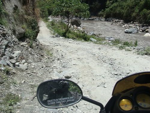


Some water crossing...

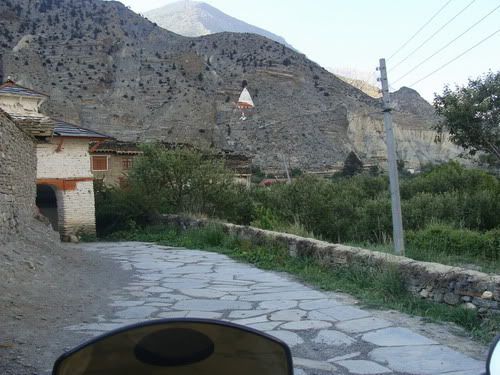
One of the village enroute...

The slush sections which are dry now...


Need i say anything?

Reach kinda half point. Tatopani translates to Hot water. Supposed to be 'danger' area from here...

At the Dana hotel. They had just the last cup of rice for me, but had truck loads of meat!!

Old lady working on something...

At Dana...
Let the torcher begin...


Wish i was on one of those...


Some village enroute. Think its Ghasa...
This was kinda big one. But made it out dry...
Nearing Lete town...

In Lete...
The horrible path to ride on...

4/4 taking short cut on river bed. No way i am going there...
Silky smooth path...

Tukche village....


The lure of the mountains....

The truckies who were encouraging me every time we meet. But then path ahead was good for them in the truck not really for a bike...

Village, electricity and mountains...

Landscape changing...

Redusing life around...


Had to wait em out

Fun riding in the narrow street of Marpha...

Prayer wheels...

Then it gets windy...
Landscape changes quickly...

The Nilgiri...
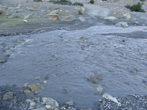
Water crossing!!

It was murky and did not know how deep it was where. So took some stones and rolled it into the water like a bowling ball so that i could guess the depth based on the rocks roll!!
Nearing Jomsom...

WOW! i make it to Jomsom in good time!!
The airport and runway visible from my room....

The runway...
Nilgiri from my window...

The sleepy and nice town of Jomsom...

Just pringles and coffee looking at the pretty Nilgiri...

It was nice time :D

Its 7.30 pm and its still bright and clear!!..

Jomsom at night...

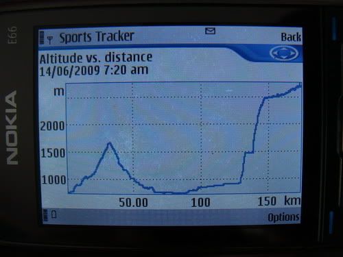
Vertical travel for the day...
5 comments:
u do look like a Nepali in that cap
: )
Mani: Well thats what the cap does :D
I went through this route from March 1 to March 3, largely comforted by your post.
I had one of the off road bikes, but believe me, it was scarier with them. I am short and had no ability to balance the bike once it stops. I fell down about ten times and lacerated my entire left leg knee down, but it was worth it.
I took two days to reach, since i started from Pokhara only by 11 AM on day 1. On the second day started from Thota Pani, went to Muktinath and returned amidst a blizzard to Jomsom. Jomsom to Pokhara was like nine hours with an additional hour of stop over at hot springs in Thota Pani
Awesome report
Awesome report. I'm thinking of doing this next week!!
Post a Comment